At 4 p.m., I realized that it was a good thing I chose to go to the hostel that provides slack packing because my overloaded ZPacks pack had a major failure. I had WiFi service, but no cell service, so I couldn't call home. Believe it or not, Facebook saved the day. I posted a request for someone to "tell my wife to send my black GoLite Jam and orange Osprey packs to the Hanover Inn," where I should be next week. Within minutes, one friend (thanks, Bear!) had sent a message to my wife, and my mother had called her. She left work immediately and went home to find my other packs, box them up and drive them to UPS for shipment (over $100 to have it delivered next Thursday; figure that cost every 50 miles or so, and it gives you an idea of how much money is going into resupply for this hike). Hopefully, I'll be able to keep the ZPacks together for the approximately 53 miles that it will take to get to the Inn.
Friday, August 31, 2018
Kinsman Notch and Glencliff NH
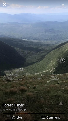
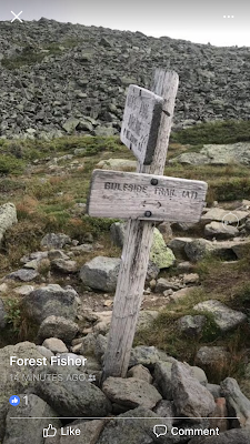
When I woke up this morning, I knew it wasn't going to be a high mileage day. My back was hurting, probably from the cold and from hiking in the rain the other night. By noon, we got as far as Kinsman Notch, where we took a break for Trail Magic and I gave my wife a quick call. I knew that there was a 6-mile stretch coming up with no water, and I didn't really want to hit it today. One option was to hitch forward to the hostel in Glencliff (Mile Marker 398.7) where my next resupply package was waiting and then come back here in the morning to slack pack back to there. Another option was to catch a shuttle to a donation-based hostel that was 6 miles away, but in the wrong direction.
Thursday, August 30, 2018
Near Mt. Wolf
Because of the thunderstorm last night, we had to stop short of the Kinsmans. On top of that, it rained through the night and into the morning, so we got a late start today. We were able to cross the Kinsmans this afternoon and passed the Eliza Brook Campsite/Shelter. About 3 miles past there, we had to stop and set up camp (approximate Mile Marker 385). We were near Mt. Wolf (elevation 3,500 feet), and it was just too cold to continue. The temperatures had dropped into the upper 40s, with a wind chill probably in the low 40s. Everything was wet, so we couldn't build a fire. I could see my breath. I took my fingers out of my bag just long enough to text my wife to send my thermal pants, down booties and gloves with the next resupply box she mails. 💨 ⛈ ☔
Here's the weather report for the next shelter we will pass.


Here's the weather report for the next shelter we will pass.

Hopefully, we'll get through Mt. Moosilauke while it's sunny!

Wednesday, August 29, 2018
Leaving The Notch Hostel, The Kinsmans and Eliza Brook
We left The Notch Hostel this morning and took their shuttle back to Franconia Notch to continue on the Trail. Our morning hike toward Lonesome Lake was relatively easy, and I felt a real sense of jubilation when we passed the last AMC hut there. We took a quick break for a drink and food to celebrate. 😆
We continued southbound on the Trail, which grew progressively more difficult, with granite slabs, boulders and tree roots. In just the last mile before Kinsman Pond, the Trail climbed about 1,000 feet. In several places, wooden steps had been bolted to the rock face because it was so steep. At about 5:45 p.m., we collected water at Kinsman Pond Campsite/Shelter (Mile Marker 377.9) and took a quick break. This was the last AMC campsite where hikers have to pay a fee to stay. Finally, we were leaving the commercialized section of the Trail that had disappointed me so much.

Just as we began to head up Kinsman Mountain, a thunderstorm started. This part of the Trail includes some aggressive climbs and descents to and from two main peaks: North Kinsman Peak (4,293 feet) and South Kinsman Peak (4,358 feet). There are several ledges along the way as well. Hopefully, it won't rain enough to keep us from reaching Eliza Brook or Eliza Brook Campsite/Shelter (Mile Marker 381.9; the last of the AMC campsites, but no fee is charged for this one), which is our target for the day.
Tuesday, August 28, 2018
North Woodstock, Day 2
The Trail is still overloaded with day hikers, section hikers and more and more northbound thru-hikers. As a result, the hostel was so crowded last night that I wasn't able to get a shower until early this morning. The owner has been really nice to me; she felt bad last night that she didn't have their "dog room" available for me, so she offered me a cot for the tent. This morning, we found a fenced-in area where I could let Forest run off leash and play for a while. He had so much fun just being a dog again; it did both our hearts good.
We were both in serious need of some rest and relaxation, and were being treated so well that I decided to spend another day at the hostel. This afternoon, we took the shuttle into town and ended up eating an American cheeseburger at a Chinese restaurant owned by Koreans. 😆😂 Once again, Forest surprised everyone when we left because he was so quiet and well-behaved under the table.

My son started Kindergarten yesterday. He went for a half-day, and tomorrow will be his first full day, with half the class. Friday will be his first full day with the whole class. We talked about it on the phone today. I'm so proud of how he is doing, but it's just gut-wrenching to be missing this huge milestone in his life. Someday I'll explain it to him. For now, I send him a rock from every place I think he would enjoy, and my wife helps him follow my progress on a map in his bedroom. He knows I'm coming back to them as fast as I can.
We were both in serious need of some rest and relaxation, and were being treated so well that I decided to spend another day at the hostel. This afternoon, we took the shuttle into town and ended up eating an American cheeseburger at a Chinese restaurant owned by Koreans. 😆😂 Once again, Forest surprised everyone when we left because he was so quiet and well-behaved under the table.

 |
| What dog? |
Monday, August 27, 2018
Franconia Notch and North Woodstock
It's funny how the thought of a resupply package can motivate me to move faster. We hiked the 10 miles to Franconia Notch in 7 hours today. Our route took us down through woods, along Garfield Ridge and up to the next peak above treeline, Mt. Lafayette (5,260 feet). From there, we followed the Trail along Franconia Ridge, across Mt. Lincoln (5,089 feet) and Little Haystack Mountain (4,840 feet), and past Mt. Liberty (4,460 feet).


We arrived at the Franconia Notch Trailhead and Flume Gorge Visitor Center at about 4:30. The shuttle into North Woodstock wasn't coming until 6:45, so I got a Coke from the vending machine and plugged in my battery pack. I was too late to reserve a room at the hostel, but they also have tents available, so we'll be staying there overnight. Mainly, I want food and a shower and recharged batteries...not necessarily in that order.


Sunday, August 26, 2018
Mt. Garfield
Our ridgewalk today took us over Mt. Guyot and South Twin Mountain. We passed the AMC's Galehead Hut and hiked up and down several minor, unnamed peaks until we passed the Garfield Ridge Campsite/Shelter, where we were able to collect water. I decided to stop for the day just past the 4,500-foot, rocky summit of Mt. Garfield (Mile Marker 363.2). Ten more miles to go tomorrow before we reach Franconia Notch and the shuttle to my next resupply package.

I'm seriously missing my family tonight and feeling so frustrated by the slow pace we've had through the Whites. I know that everyone says your average mileage for the rest of the Trail will be cut in half here because of the number and magnitude of the peaks and rocks, but facing that hasn't been easy. I can't wait to break free of New Hampshire and start making miles again.

Saturday, August 25, 2018
Crawford Notch to Franconia Notch
Note from Admin:
We have not heard from Fisher since yesterday (Friday) morning. They were headed back under the treeline after leaving Mt. Eisenhower (the next peak soon after the Lake of the Clouds Hut), where cell signals may have become more problematic. It is also possible that his battery pack has been used up. He expected to arrive at the next hostel on his schedule for resupply tonight or tomorrow morning, so we should hear from him soon. Stay tuned!
We have not heard from Fisher since yesterday (Friday) morning. They were headed back under the treeline after leaving Mt. Eisenhower (the next peak soon after the Lake of the Clouds Hut), where cell signals may have become more problematic. It is also possible that his battery pack has been used up. He expected to arrive at the next hostel on his schedule for resupply tonight or tomorrow morning, so we should hear from him soon. Stay tuned!
Thursday, August 23, 2018
Finishing the Presidential Range
We left Lakes of the Clouds Hut this morning and headed back south to finish the Presidential Range and head toward Crawford Notch. New Hampshire is not that difficult as far as hiking goes. If you are a day hiker and do not know what you are doing and have a lot of money to spend, then you will love it here. If you are an AT thru-hiker, you will find this beautiful landscape ruined by the amusement park the White Mountains have become. Mount Washington is just one more tourist trap. Most of the thru-hikers I've spoken with seem to feel the same way. I'll be glad to leave New Hampshire if this is any indication of what the rest of the state is like.
Wednesday, August 22, 2018
The Whites and Unpredictable Weather
One of the most frustrating aspects of my hike has been the rapidly changing weather we've experienced in almost every state. All of my careful planning of food and the timing of supplies for me and Forest, and all of my wife's hard work on resupply shipments, can be completely undermined by a sudden change in temperature, storms, wind and wind chill. The forecast for today is yet another example.

This morning I had to make the difficult decision to stay put for another day. I have to weigh risk versus mileage gain, and today the risk is just too high to continue hiking above treeline around Mt. Monroe and onward over Mts. Franklin, Eisenhower, Pierce and Jackson. It's supposed to clear tomorrow and the winds are supposed to decrease, so we will push on then to get below treeline.
I ended up paying $15 and sleeping on the dining room floor last night because they were filled to capacity. I had to get up and pack by 6 a.m. so they could set up breakfast for the strange rich people who are willing to pay $120 for a bunk. Then I was able to sit at the table until they set up for dinner. Tonight at 9:30 it will be back to the dining room floor and then up and out early tomorrow. We are allowed to help ourselves to any leftovers, though. After a day of weird day hikers all trying to one-up each other, I'm ready to be back on the Trail. I think Forest is ready to be off the clock for a day, too; he hasn't had much play time lately. We're looking forward to the end of the Whites.
At about noon today, representatives of the Appalachian Mountain Club (AMC) approached us and told all of the thru-hikers that they didn't have room for them today/tonight and they had to leave...in this dangerous weather. I calmly told them no and to go ahead with whatever steps they needed to take next, but that I would sue if they forced me out in dangerous weather. Amazingly, a spot suddenly opened up. Appalachian Mountain Club, aka the Appalachian Mountain Monopoly Club.
In the meantime, here are some more photos from yesterday. I enlarged the last one so you can appreciate what I mean by a rock scramble.


Tuesday, August 21, 2018
Mt. Washington
We slept in the alpine zone last night. It was cold, but tolerable. I still don't recommend it, though. It took a while to dry everything out this morning so we could pack up camp. As soon as we could, we resumed our climb toward the summit of Mt. Washington. I guess this is what they mean by "having your head in the clouds."


We only had a little over a mile to go. Rocks were strewn all over the ridgeline, but compared to what we've been through, this didn't seem so bad. We were almost entirely enveloped in clouds when we got to the top.


And then the sky cleared. 6,288 feet. I think Forest captured the triumph we both felt.

The Mt. Washington State Park Sherman Adams Visitor Center is located at the summit of Mt. Washington. The building also houses a cafeteria, restrooms, gift shops, and the Mount Washington Observatory and museum. After hitting the ATM, we stopped in the cafeteria for pizza. According to the Observatory, the forecast for tonight and tomorrow was deteriorating, with rain, thunderstorms and winds increasing to 35 to 50 mph with gusts up to 65 mph. Based on that, I made the difficult decision to spend the night in one of the AMC huts (around Mile Marker 332). At that particular hut, the Backpacker Space (also known as "The Dungeon") is available for thru-hikers at the regular rate of $10 per night. Space is available on a first-come, first-served basis. We received a pillow and blankets, which were a necessity even to those of us with sleeping bags because the bunkhouses are not heated and have no electricity. We also were allowed to eat any leftovers from the dinner and breakfast services they provide to the high-paying customers. Oh, and we had cold running water (anyone for a brisk sponge bath?) and a 9:30 p.m. curfew. At least they understood that Forest was not classified as a pet (they have a no pet policy) and didn't question his right to be there with me.
Speaking of Forest, we have officially been together 1 year now! On August 20, 2017, I met him for the first time at Canines for Service and began my team training with him, and on August 24, he came home with me. I think he's as happy to be by my side as I am to have him there.


We only had a little over a mile to go. Rocks were strewn all over the ridgeline, but compared to what we've been through, this didn't seem so bad. We were almost entirely enveloped in clouds when we got to the top.


Speaking of Forest, we have officially been together 1 year now! On August 20, 2017, I met him for the first time at Canines for Service and began my team training with him, and on August 24, he came home with me. I think he's as happy to be by my side as I am to have him there.
Monday, August 20, 2018
Mt. Madison, Mt. Adams and Mt. Jefferson
We left the campsite yesterday afternoon, hiked through forest for a few miles, and made the very steep 3,500-foot climb up the side of Mt. Madison, out of the treeline and across the rocky ridgeline. By the time we reached the summit and passed the AMC Madison Springs Hut, it became evident that the rock scramble we were facing from Mt. Madison to Mt. Adams was just too risky to continue for the night. We decided to camp at the Valley Way Campsite and push forward toward Mt. Washington tomorrow night. I was beat and finally crashed at about 3:45 a.m.


We slept as late as we could this morning, anticipating another late afternoon into night hike. Part of the reason we are trying to hike the major summits at night is that the Trail is still loaded with day hikers trying to get in a few peaks while the weather is good. The Trail is narrow and the alpine environment is fragile (so leaving the Trail even by a few feet is discouraged); add in lots of folks going both north and south and trying to pass each other, and it makes it harder to stay on course and navigate the path safely.
On mornings when I'm tired, it's always harder to get motivated and push on. Forest helps me through those moments.

We headed out before sunset to get across the worst of the rock scramble before dark and headed toward Mt. Adams and Mt. Jefferson.


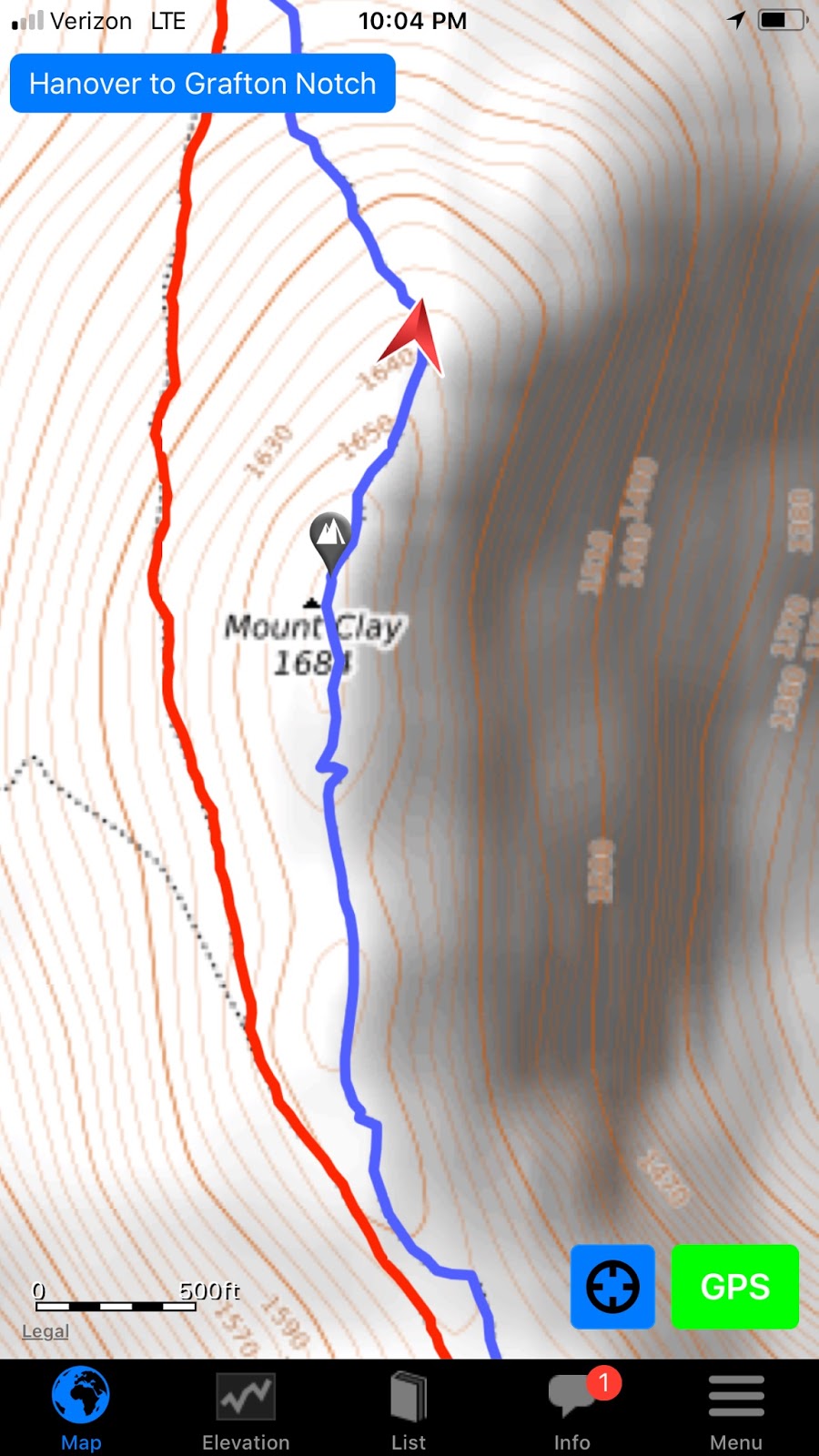
By 8:30 p.m., we were approaching Mt. Clay, which was the last mountain before Mt. Washington, the highest peak east of the Mississippi River and north of North Carolina. Unfortunately, Mt. Washington is known as the "Home of the World's Worst Weather," and by 10 p.m. the temperature unexpectedly dropped below freezing. We detoured down the blue blaze trail to Mt. Clay to camp below treeline for the rest of the night. We'll be warm in our hammocks, as my wife sent all of our cold weather gear back to me right before we entered the White Mountains.


On mornings when I'm tired, it's always harder to get motivated and push on. Forest helps me through those moments.


Sunday, August 19, 2018
Into the Presidential Range
Today I have a 5-day supply in my pack, and we are headed into the beginning of the Presidential Range of the White Mountains, which includes the highest peaks in New England. In 4 miles there is a 12-mile stretch above treeline, which includes Mt. Madison (5,366 feet), Mt. Adams (5,799 feet), Mt. Jefferson (5,712 feet) and Mt. Washington (6,288 feet). The greatest climb is the initial one up Mt. Madison, about 3,500 feet. No camping is allowed above treeline, and there is a 7-mile stretch without a water source. I plan to be up there for the sunset and will hike on into the night until we get back below treeline at a water source. The weather today is great. The White Mountains are beautiful, but so far not that tough after all the hype I have been hearing from other hikers.


Forest continues to look great and appear right at home on the Trail.

Some Thoughts Looking Back on the Descent Down Wildcat Mountain
Some of you may not know that I grew up in the mountains. Hiking, fishing, anything to do with nature has run in my blood since birth. There's not much outdoors that scares me except maybe trees falling in the dead of night and lightning, and I look at each new situation on the Trail as just another challenge to figure out and tackle.
People warned me not to go down Wildcat Mountain with Forest. Then, when they figured out that he and I have been connected the entire way and we were going to go down Wildcat connected they told me one or both of was going to die. They said to go down the ski lift. So, we hiked down. Connected the entire way. I actually fell once—while standing still on wet rock and taking a drink of water. A simple slip; it had nothing at all to do with Forest. It didn't hurt that much, and I got up, and we hiked on. Just another day in the woods.


People warned me not to go down Wildcat Mountain with Forest. Then, when they figured out that he and I have been connected the entire way and we were going to go down Wildcat connected they told me one or both of was going to die. They said to go down the ski lift. So, we hiked down. Connected the entire way. I actually fell once—while standing still on wet rock and taking a drink of water. A simple slip; it had nothing at all to do with Forest. It didn't hurt that much, and I got up, and we hiked on. Just another day in the woods.


Saturday, August 18, 2018
Wildcat Mountain to Pinkham Notch and the AMC's Joe Dodge Lodge
We spent some time waiting for the weather to clear this morning. It was raining when we got up; just as it stopped and we were ready to get going the wind picked up. I finally made the call to head out at about 11 a.m. because we need to get to Pinkham Notch for my next resupply package before I run out of food for Forest. I'm hoping to pick up my package, repack quickly and get back on the Trail. A 12-mile stretch that is above treeline with no water sources and a heavy pack is coming up. We won't be able to stop in the middle of that section, so I want to get as close to the beginning of it as possible today.
We climbed the remaining peaks (there are 5 total—A/B, C and D/E) of Wildcat Mountain, crossing several bog bridges. At the summit, there was a wood platform, from which we could see Pinkham Notch and Mount Washington. As we crossed the summit, we came to Wildcat Ski Area, the site of the first enclosed gondola lift in North America. The hardest part of today's hike was the descent down the western slope to Pinkham Notch, which drops 2,000 feet in 2.1 miles. This section included steep, unprotected sections of open ledge and large wooden steps, so I had to slow Forest down and be very careful descending.

Once we got to the bottom, it was just a mile to Pinkham Notch and the AMC's Joe Dodge Lodge, where my resupply package was waiting. I recharged my battery pack while I ate and repacked, and then headed about a half-mile down the Trail in the dark to stealth camp.
We climbed the remaining peaks (there are 5 total—A/B, C and D/E) of Wildcat Mountain, crossing several bog bridges. At the summit, there was a wood platform, from which we could see Pinkham Notch and Mount Washington. As we crossed the summit, we came to Wildcat Ski Area, the site of the first enclosed gondola lift in North America. The hardest part of today's hike was the descent down the western slope to Pinkham Notch, which drops 2,000 feet in 2.1 miles. This section included steep, unprotected sections of open ledge and large wooden steps, so I had to slow Forest down and be very careful descending.

Friday, August 17, 2018
Zeta Pass to Wildcat Mountain
We've been trying to outrun the rain all day. We left Zeta Pass and headed toward Mt. Hight, which is supposed to have some of the best views in the Whites. Even with the overcast weather we had today, the area was absolutely beautiful. Because of the wind and clouds and rock surface, the Trail over Mt. Hight (4,675 feet) was a little confusing, but we were able to figure it out using landmarks and our GPS tools.

Still ahead of the rain, we pushed on to Carter Dome (4,833 feet). Fortunately, this peak is not bald, so the trees provided shelter from the wind and wet clouds. We followed the Trail down the other side and stopped to have lunch at one of the vistas. The view of the notch and Wildcat Mountain was a little intimidating. We were going just about straight down and would then be climbing straight up a rockfall...steep down, steep up. I looked at Forest and, as usual, his tail was wagging wildly as if to say, "I'm ready; let's go!"


Down in the notch there is a hut managed by the Appalachian Mountain Club (AMC). It's one of a series of huts and lodges in the White Mountains. They are available to members of the AMC for one price, and to nonmembers for another—in this case $94/$112 (granted, the money goes to maintain the Trail). That price includes breakfast and dinner, running water (cold only) and composting or waterless toilets. However, the huts are completely off the grid, so they have no heat, lighting, WiFi or electrical outlets. So, they are essentially glorified shelters with meals. No one is allowed to have a shelter of any other kind in the Whites, so thru-hikers are forced to carry larger than normal amounts of food if they can't afford the AMC prices (we are offered the member price, but that's far out of reach of most hikers who are already strapped). If there are leftovers after a meal, they are placed in a hiker box that we can access, and they do offer two work-for-stay positions per night (if work is available), but they go to the first two thru-hikers who want them; timing is everything. You can't count on either of those options being available, so you have to plan as if your only option is what you pack in. Now, water at this particular hut is blocked off for the hut, and hikers aren't allowed to camp within 200 yards of a hut. 200 yards of this particular hut puts us on the almost vertical side of Wildcat Mountain with no water. Are you starting to get the picture?
It's about 5:30, which is too late to be hiking up another vertical slope with rain and wind coming. We found another water source that will do and set up camp nearby. This puts us at about Mile Marker 314.5.


 |
| The rockfall we will have to climb on Wildcat Mountain |


 |
| View of Carter Notch Hut (an AMC Property) before we climbed down |
Subscribe to:
Posts (Atom)
How It All Began
In August 2017 Canines for Service Inc. in Wilmington, NC, provided Service Dog Forest to me (U.S. Army Veteran "Fisher"). It was ...
