We left camp this morning, and headed along the ridges for 4 miles up to Smarts Mountain (elevation 3,200 feet). The views were beautiful from the summit, which included a fire tower and the Smarts Mountain Cabin Shelter (Mile Marker 418.8), which used to be the fire warden's cabin. I decided to take a break there for lunch and called my wife while I had a cell signal.
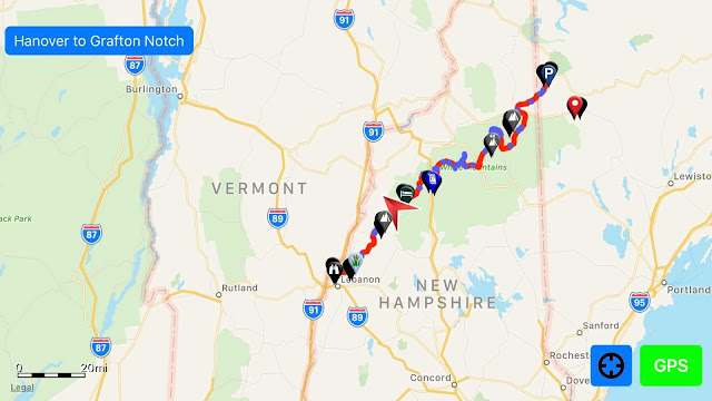
The hike down the mountain was quite a bit steeper than the climb up had been. We walked across Lambert Ridge and down to the Smarts Mountain/Dorchester Road Trailhead, where we crossed Grant Brook. After a couple of miles, we passed Trapper John Shelter (Mile Marker 425.5), which was named after the character from the TV show M*A*S*H*. Then, the Trail climbed steeply to the top of Holts Ledge (elevation 2,110 feet) and then dropped just as steeply down the other side. We crossed Hughes Brook, where we decided to collect water and camp near Goose Pond Road (Mile Marker 428.2). We totaled about 13 miles for the day.
Wednesday, September 5, 2018

Mt. Cube and Hexacuba Shelter
Yesterday, we continued past Ore Hill (where we crossed Ore Brook) and Sentinel Mountain and hiked through Sentinel Mountain State Forest. Each time we cross a brook or stream, I let Forest stand in the water to cool off a little, so that helped us keep moving. We stopped to collect water from the Pond Brook, which connects Upper and Lower Baker Ponds, near Bakers Hill Rd. (NH 25A) and set up camp nearby for the night.
This morning we had to hike a long 6-mile stretch where there was no reliable water source, so we were carrying extra water. The Trail rose gently for about a mile after crossing the 25A Trailhead (Mile Marker 408.5) and then began to climb more steeply to the rocky summit of Mt. Cube (elevation 2,909 feet). We took a quick break there for lunch and to speak with my wife briefly while I had a weak cell signal.

The descent down Mt. Cube included granite slabs and a rockfall, so we were glad it wasn't raining. Not far down the Trail we passed Hexacuba Shelter and crossed Jacobs Brook. We decided to collect water and camp there, leaving Smarts Mountain for the morning.
This morning we had to hike a long 6-mile stretch where there was no reliable water source, so we were carrying extra water. The Trail rose gently for about a mile after crossing the 25A Trailhead (Mile Marker 408.5) and then began to climb more steeply to the rocky summit of Mt. Cube (elevation 2,909 feet). We took a quick break there for lunch and to speak with my wife briefly while I had a weak cell signal.

Monday, September 3, 2018
Wachipauka Pond and Mt. Mist
Our hike today took us on a leisurely walk down the Trail, winding through the forest and up and down gentle hills. We passed Wachipauka Pond and went up and down Mt. Mist. It was a relatively easy day, but now that we're in lower elevations, the heat is slowing Forest down. It's been in the low 80s, so we've been taking frequent drink breaks. The temperatures are supposed to drop significantly later in the week, so we'll be able to move faster and farther then.


Our goal for the day was just past Mt. Cube and Hexacuba Shelter, which would be 15 miles. I'm not sure if we'll make it that far because of the heat. Forest will be calling the shots.


I forgot to recharge my phone last night, so I have to save what is left for Guthooks.
Sunday, September 2, 2018
Leaving Hikers Welcome Hostel, Glencliff, NH
After I got up this morning and had breakfast, I began to work on a way to fasten the hip belt back onto my pack, since it still has to get me to Hanover, NH, about 44 miles away. I was able to fix it for now using a piece of metal I filed smooth. It's probably hard to tell from these photos, but in the top two pictures, you can see the pack, the part that broke and the hip belt (all lying on blue carpet). The bottom picture shows the piece of metal that I used to reattach it.


After making a dinner run, I was ready to pay my bill at the hostel and head back down the Trail. Hikers Welcome Hostel was a good place to stay, but they only had bunkhouse and camping options. We stayed in the bunkhouse. As usual, I didn't sleep well in a room full of strangers, but I was glad to have a bed instead of having to sleep on the ground.
I plan to just hike 1.7 miles around Wyatt Hill tonight. Tomorrow, we'll get an early start and hopefully knock out 10-15 miles.


I plan to just hike 1.7 miles around Wyatt Hill tonight. Tomorrow, we'll get an early start and hopefully knock out 10-15 miles.
Saturday, September 1, 2018
Slackpacking from Kinsman Notch to Glencliff, NH (NH 25/Moosilauke Rd.)
We headed out to slack pack the section we shuttled over yesterday at 8:30 this morning. This section included Mt. Jim, Mt. Blue and Benton State Forest, but the major attraction was Mt. Moosilauke, the southernmost high peak in the White Mountains (elevation 4,802 feet). Beginning at Kinsman Notch and hiking south, Forest and I hiked about 10 tough miles in 4 hours. Climbing up Mt. Moosilauke was essentially climbing up a waterfall, which we had to do very carefully. It wasn't fun; I'm so glad to be done with the White Mountains.

We have now hiked 1,108.3 miles, which means that we are over the halfway mark for the Trail. The hardest parts are done, and in about 40 miles, we'll say goodbye to New Hampshire and hello to Vermont.
We got back to the hostel in Glencliff in good time. I got a cheeseburger for dinner and began working on my pack, so it will make it through to Vermont. The good news is that ZPacks has said they will fix my pack no matter what happened to it. It's great working with these companies that are so supportive of hikers.


Subscribe to:
Posts (Atom)
How It All Began
In August 2017 Canines for Service Inc. in Wilmington, NC, provided Service Dog Forest to me (U.S. Army Veteran "Fisher"). It was ...
