Friday, September 28, 2018

Final Decision

Here are some important statistics for you to understand, when you think about my hike:

  • Out of about 4,000 people who attempted an Appalachian Trail thru-hike this year, only about 20% will complete it.
  • Of those 20%, the number that will finish with a dog can be counted on one hand.
  • Of all of the people who I have seen thru-hiking with dogs, 100% make their dogs carry all of their own food and supplies. I pack almost all of Forest's stuff (i.e., hammock, under quilt, top quilt, straps, five days of food, coat, rain jacket, service dog vest and gear, canine first aid kit, tons of water, ear cleaner, paw care stuff, nail care stuff; I am certain I forgot some). When we walked into and out of towns and Forest was in his formal Canines for Service vest, I also carried his pack on top of my pack. He only carried a two-day supply of food and a first aid kit in case of emergency. 
  • All but one dog that I know of that have finished the thru-hike were white. Only one was a black dog. Black fur means they overheat more easily, so they require more caution, slower paces and shorter days when it's warm. That's what took us off the Trail in June.
  • Almost all of the dogs I have seen were allowed to wander off leash at all times. My dog and I hiked connected by leash the entire time. Where I had to be careful for my own safety, I had to be doubly conscious of Forest's safety. The other dogs ate anything they were given or found on the ground, and if they got hurt or couldn't make it, they were sent home and the hiker continued. That will never be an option for me with Forest.
  • I have a plastic disk in my back with two fusions. On a good day, I typically am in pain. On the Trail, if I slept wrong (especially when I wasn't able to sleep in my hammock or a bed), carried too much weight or distributed it or lifted it wrong, or just had an overly difficult day where I was climbing up and down and around boulders or other obstacles, that pain was multiplied.
  • I was in need of surgery for a cataract in my right eye before I left for my hike. That meant that I was operating with impaired vision every day.

None of that mattered to me, and I went into this hike fully aware and still doing it all willingly. Forest does so much for me, the least I can do for him is to make sure he is happy and healthy every step of the way, and not overburdened in a way that could damage his joints. I'm not as young and agile as I was when I first did 1,200 miles of the Trail, but I still had the will and desire to hike. All of these things did slow me way way down, though.

To compensate for the extra dog supply weight that I was carrying, I found myself (sometimes consciously, sometimes unconsciously) packing less and less food for myself. As a result, my personal weight is now down to 152 pounds; a 20-pound weight loss, when my friends and family said I was thin already. Still, "Can do," I said.

However, I have had two major issues on the Trail that were completely beyond my control:

  • One: repeated access issues and the general attitudes I have seen toward Forest in most towns. Shuttle drivers from the Trail to my resupply points in town have turned me away because I have a service dog. Hostels have refused me. They don't care that Forest is a legitimate, trained service dog that I rely on for not only my overall peace of mind, but also for physical support. They only see yet another big, hairy dog in a long line of pets, emotional support animals and fake service dogs that have made it harder for them to do business.
  • Two: I started my thru-hike March 2nd. At the slow pace we have been going, we would not complete the thru-hike until mid-December. This is just too much time away from my family.
Anything that is added to this list in terms of additional pack weight, or barriers or logistical SNAFUs really, really, really compounded things for me. And I haven't coped well with that.

So, after days of thought and indecision, it is time to stop. We gave it one hell of a shot. I now have about 2,500 miles of this Trail under my belt, combined by my previous start and this attempt, and Forest has almost 1,400 miles (including, by far, the toughest miles on the Trail) on his paws. I texted my wife yesterday and, as always, she dropped everything to come get me. About six more hours as of this writing, and I will be in our truck with my wife and son on my way to a hotel in Pittsfield, MA, for the night. Tomorrow, we will drive back home to near Charlotte, NC. Right now, I feel like I have won a million dollars, but I have to wait for the check to clear before I can have it.

Thank you all for your support. I know you have all been invested in my journey, or you wouldn't have been reading this blog for months. I'm sure you share my mixed feelings. Please know that your time was not wasted. I learned a great thing. I thought I hated all people. Now, I know I just hate most people. 🙂 Seriously, though, I cannot thank you all enough. Goodbye...at least for now.

Wednesday, September 26, 2018

Wrestling with Myself

Today I had a near meltdown after my gracious hosts delivered me back to the trailhead. I announced to friends and family that I was calling it quits and taking a bus home when I got to Great Barrington. Then, I texted my wife to see what it would cost to get to the nearest bus station (there was actually one closer than Great Barrington, in Pittsfield) and the cost to get home.

When I was wrestling with myself, I wasn't really clear on what was making me crumble. Looking back, I realize there were a few things. The really minor one was that when I picked up my resupply package yesterday, it didn't include things I had asked for and I got upset. As it turns out, the package had been opened and retaped, either as a result of an accident with the package or an intentional theft. Definitely not enough reason by itself. The really major cause centered on things that had been happening at home. First, my son started Kindergarten, and I wasn't there to encourage him. Second, he got sick several weeks ago with croup and strep throat and had to be hospitalized for several days, and I wasn't there to console him. Third, Hurricane Florence threatened Charlotte with flooding, and my wife had to handle all of the preparations herself, and evacuate my family at 8:00 at night to higher ground as the river behind our house rose. All of the feelings that had been lurking in the back of my mind for the past weeks suddenly became overwhelming. They almost broke me.

I really wanted to quit and maybe I should have, but something in me wouldn't let me and that is really aggravating. After many texts back and forth with my wife, I decided that I am going to keep going until either that thing lets me quit, or I finish the hike. I was just so over it today. I miss my kids. But like I said before, I need to have the ability to back myself when I say to them, "Don't quit."

And this is the challenge of the trail. For a while the battle is with the weather and gear and terrain and your legs and all the other small things like cooking and getting water and planning and executing that plan and so on. Then, you conquer those things one by one and that is when the real challenge hits: yourself.

I remember seeing NOBOs (northbounders) with about 400 miles left and saying, "Hey, congrats! You're almost done!" They had an absent look about them, and they would say what I feel now, "Only 400?! I don't feel like I'm almost there." Sometimes the finish line on the trail feels farther away the closer you get. After 1,300 miles, 1 mile equals 10. Small towns become big cities; misery gets magnified. I'm sure that at some point closer to the finish line that will flip, and I'll get a second wind, like I did before the Mahoosuc Notch and before the White Mountains. Until then, whenever that is, ugh...I push on.

Body and mind say quit loudly. but I knew the doubts would come. I really thought it would happen sooner. I began to think it might not happen at all, but clearly today it did, and now I have to laugh. Because all right then, to hell with whatever in me is telling me to quit. Show me what you've got, and I'll show you what I've got. It's not going to be a pretty fight, but I'm gonna win. The finish line is mine. I know it because I saw it before I started. 😆

Tuesday, September 25, 2018

And Another Day in Dalton

Once again, control of my schedule is in the hands of the weather. A front is moving in that is supposed to bring heavy thunderstorms through Wednesday. I picked up my resupply box today and redistributed my pack. For the remainder of the day, I looked over the Guthooks maps for the next 50 miles and tried to plan. The terrain didn't look too bad, so hopefully I'll be able to make up for lost time. As much as I appreciate the hospitality of my hosts, I'm keenly aware of every delay in my hike home.

Monday, September 24, 2018

Dalton, Massachusetts

Over the past days we made our way down to Dalton, Massachusetts, through Cheshire, the Cobbles, North Mountain and Weston Mountain. The nights in the upper elevations have gotten much colder, down in the low 40s, with an even lower wind chill. By the time I got to Dalton, I just wanted to warm up. Forest didn't have his warm jacket yet either, it's being sent to our next stop after Dalton. One thing I've learned from this experience: I don't ever want to be homeless. I'm just too old to live like this long-term.

Speaking of Forest, he finally ripped a hole in his hammock. I can't really complain; it lasted almost a thousand miles.


I decided to take the friends of a friend up on an offer for food and a real bed. They picked us up and took us back to their house, where a private room and bathroom were waiting for us. After a long, hot shower, I felt more human again. Dinner was great, grilled salmon. I hadn't had that in a while. They even told me I could let Forest sleep in the bed, too. Good people.

I slept hard for 9 hours. I can't remember the last time I slept that long. And, I woke up to real coffee and an omelet. My hosts offered to let me stay another day to pack in some calories and do my laundry, and I decided to take them up on it. Tomorrow morning, they'll take me back to Dalton to the Post Office, where I'll pick up my resupply package, repack and head back out on the Trail.

Oh, and by the way—we've gone 1,330 miles, with 770 to go! Home is beginning to sound much more real now.

Saturday, September 22, 2018

Goodbye, Vermont! Hello, Massachusetts!

Last night it felt like I was sleeping on a boat on rough seas rather than in a hammock. We stayed warm and dry, though. It felt good to have put in a 14-mile day.

This morning, I was glad to see that the weather improved because it had been slippery walking on the wet leaves all day yesterday. We passed into Massachusetts, where the Trail winds through the Berkshires for 90 miles. For the first miles, we continued walking through the green tunnel, up and down along ridgelines. When we reached East Mountain, we walked along ledges and had a great view of the countryside to the west and a town to the east. We took a quick break and then continued along the ridge through Clarksburg State Forest and began to descend down to the town of Greylock.

When we reached Greylock, the Trail went along Massachusetts Avenue for a short time, and then turned and took us across a bridge over the Hoosic River and then a pedestrian bridge over MA Route 2, Mohawk Trail. Towns are always tempting, and this one offered a grocery store and a diner, but at this point in my hike I have one focus: home.

Almost immediately after we left the town of Greylock, the Trail started to climb toward Mount Williams, the first peak in Mount Greylock State Reservation in the Berkshire Mountains. The ascent was gradual for about a mile, and then it climbed steeply 1,500 feet up a ridge for a little over a mile to an unnamed peak. At that point, the Trail turned eastward past Wilbur Clearing Lean-to and took a steep descent down to Greylock Mountain Road, after which it climbed steeply again to the top of Mount Williams (elevation 2,956). We weren't done yet. Another steep descent down into a saddle, followed by a steep climb almost to the top of Mount Fitch (elevation 3,110 feet). One more shallow climb down and another steep climb up, and we had finally reached the peak of Mount Greylock (elevation 3,491 feet), the highest mountain in Massachusetts.

We stopped for lunch at the top of Mount Greylock. It's a strange combination of commercial (there's a lodge and a ski trail) and commemorative (there's a 93-foot-high Massachusetts Veterans War Memorial Tower in memory of World War I Veterans) and historic (Herman Melville supposedly said the shape of the mountain was his inspiration for writing Moby Dick). The spiral staircase leading up inside the Veterans Memorial was definitely more than I wanted to tackle after hiking here, let alone Forest. Instead, I sat behind the memorial, ate lunch and enjoyed the view, while Forest (guess what?)...napped.

Photo Credit: Geoffrey Coelho Photography

After lunch, we hit the Trail, which dropped down to two trailhead/parking areas and then climbed and followed the ridge over four peaks comprising Saddle Ball Mountain. I liked this area better because it was quieter; Mount Greylock still attracts tourists at this time of year. I noticed that there was greater variety in types of trees here, which was refreshing. As we descended down from the last peak we came to Mark Noepel Shelter (Mile Marker 607.2). I collected water, fed Forest, made my dinner and set up camp. Another 14-mile day was completed, and I was ready to sleep.

Friday, September 21, 2018

Congdon Shelter, Lake Hancock and Seth Warner Shelter

I was determined last night to get on a regular schedule that would keep me pushing toward home. My new cell phone alarms are 5:30 for coffee, 6:30 to pack up camp and 7:00 HIKE HOME! Forest seems well-rested and ready to go, too. Part of the reason I stayed put yesterday was to give him a break to rest his paws; the day before he had done a lot of gravel road walking. Today looked like it was going to be rainy and muddy.

After we left camp this morning, the Trail began an immediate steep climb from about 1,200 feet up Harmon Hill to about 2,100 feet in less than half a mile. For about 3 miles, we followed ridges with minor changes in elevation and crossed three streams. When we reached the Congdon Shelter (Mile Marker 582.8), we took a quick break to collect water. Then we continued down the Trail, which followed a series of streams and passed Lake Hancock, where we stopped for lunch.

Back on the Trail, we started climbing up and down another unnamed peak (elevation 2,844 feet). At the bottom, we passed a small pond and then hiked over two unnamed peaks before starting the ascent up the highest summit of the day (elevation 3,026 feet). The descent from that peak took us to the last shelter in Vermont, the Seth Warner Shelter. Just past the shelter was a stream from which I was able to collect water before I set up camp for the night and made dinner. A thunderstorm was rolling in and it was chilly and windy, so I set us up with the tarp closed in tight and climbed in to get warm. The next two days are supposed to be a little nicer.

Thursday, September 20, 2018

Back to the Bennington Trailhead

I was up by 7 this morning because I had a lot to do before I checked out of the Catamount Motel. I had to unpack my resupply package and redistribute things in my pack. Then, I had to download the next section of Guthook maps for Massachusetts to my phone, figure out my next resupply stop beyond the one already set up and let my wife know what that would be. When she asked me how I was feeling today, I said, "Ummmm...like coming home. Duh!" Yeah, I can be a smartass sometimes.

Part of my resolve to continue this hike has decreased, but there is one very important reason that motivates me to continue. I have a 5-year-old son. If I were to quit before I finish, I'd be telling him that it's okay to quit and give up. He's watching what I'm doing so carefully; I don't want to lose credibility with him, so I need this hike to be an important lesson for him.

The hiker that had stuck with me since Maine decided this morning that he just couldn't afford to continue any longer. He was out of funds and needed to go back to work, so he hitched to the bus station. I had mixed feelings about his leaving. It was less stressful for me when he was along for the toughest parts of the Trail, in case I needed help lifting or lowering Forest, and knowing he was there was definitely comforting to my family and close friends. I definitely appreciated that. On the other hand, we had been sharing some of my resources, so being back on my own would allow me to plan logistics better (e.g., how long food would last, battery pack life). It sure seems quiet now.

Once I got my pack and the plan for the next section squared away, I checked out of the motel and a member of the staff drove Forest and me back to the Molly Stark Trail Trailhead. A branch of the City Stream ran along the road from town and past the trailhead. It was already afternoon, so I decided to camp along the Trail for the rest of the day to tie some flies, chill out and let my mind wander for a bit. I haven't done that for so long, so I really enjoyed the peaceful afternoon. It was like hitting a reset button for me.

I had forgotten how much I hate camping near roads. Weird, random things always seem to happen. After I collected water and was getting ready to make dinner, someone walked up next to me and asked if I wanted a hit on what he was smoking (it was NOT a cigarette). Pot's legal here and people smoke it openly, but it's bizarre when you're not used to it. I said no thanks, and he walked away. I texted my wife about it and gave a very detailed description of the person and his friend, just because they didn't look like hikers, seemed a little strange and had set up their camp so close to mine. Then, I went to cook my dinner. A few minutes later, I picked up my phone and saw that there were about four texts from my wife, each with increasing concern, and one missed phone call. It seems that my detailed description of two sketchy guys camping near me for no apparent reason sounded like a crime scene, and then my failure to respond to her texts were met with alarm. She was mad at first, but then we laughed about it. Just one more thing she has to put up with when I'm on the Trail. 😱😁

In just 42 miles, I'll be leaving Vermont, entering Massachusetts and moving on to my next Guthooks map section, which covers Great Barrington, Massachusetts, down to the Delaware River in Pennsylvania. The states will be going by more quickly now, and I know that will be motivating for me.

Wednesday, September 19, 2018

Bennington, VT

Because of the rain over the weekend, I didn't make as much progress as I had planned and was low on food by yesterday. I ate half of a meal last night for dinner, and had the other half this morning for breakfast. I always have an extra day of food for Forest, so he had his regular meals. We started out from the shelter at about 9 a.m.

Today's hike began with a fairly steep descent from Glastenbury Mountain, followed by tiring climbs up and down a series of minor peaks. About a halfway into the day's hike, we climbed up Little Pond Mountain (elevation 3,748 feet) and took a short break. I knew I wouldn't be eating again until we reached town tonight, so I didn't want to delay. In addition, we were in a 4.5-mile stretch with no water source.

The second part of our hike took us down the mountain and across a ridge that passed by Little Pond. We continued across several more peaks and then descended gradually to Hell Hollow Brook, where we collected water and took another brief break. Then, we proceeded up Maple Hill, after which the Trail dropped steeply past Melville Nauheim Shelter. I had been instructed to contact the motel we were headed for when we were 1 mile out, but I didn't have a strong enough cell signal. Instead, I texted my wife and asked her to make the call and continued on down the steep path to the VT 9 Trailhead. At about 3 p.m., we were picked up by the shuttle and taken to the motel. A little dog in the office barked at Forest as we checked in and got my resupply package. As always, Forest just ignored it and set the perfect service dog example. After I dropped our gear in the room, I cleaned up quickly and headed out to eat. I was exhausted and dehydrated; I'd be dropping into bed early tonight.

Tuesday, September 18, 2018

Story Spring Shelter, Kid Gore Shelter and Goddard Shelter

It was raining when I woke up this morning, so I waited a bit to see if it was going to let up or clear. It didn't stop, so I decided to push on, thinking that I would be in town at the end of the day. After collecting water and having breakfast, we left the trailhead. The day's hike began with a short descent, followed by a gradual climb for about 4 miles to the Story Spring Shelter (Mile Marker 559.5).

It was still raining, so we took a quick break and continued on. We proceeded downhill and passed a pond. The Trail crossed two streams and leveled out for a bit, and then began to climb and follow around the side of several unnamed mountains at about 3,000 feet. We crossed several more streams and arrived at Kid Gore Shelter (Mile Marker 564.1), where we collected water and took a break for lunch.

After lunch, we resumed hiking and the Trail began to climb again. We walked up and down across three unnamed mountains, finally climbing to the top of Glastenbury Mountain (elevation 3,745 feet) and past the fire tower. About a third of a mile down from the peak we came to the Goddard Shelter, where I decided to stop for the night. I was wet and tired and missing home.

Monday, September 17, 2018

Stratton Mountain

Note from Admin:
Between cell service issues in Vermont and the hurricane in North Carolina, we had some delayed messages that ended up confusing the timeline and miles covered in our blog entries. Rather than try to sort it all out, correct previous entries and add skipped information (which would probably just confuse everyone), we are going to pick up at Forest Fisher's current location a little farther along in Vermont and move forward.

We got an early start and headed out down the Trail hoping to travel about 15 miles. We spent most of the morning hiking through the green tunnel with very few chances to see out of the woods to get my bearings. After hiking about 5 miles the forest thinned out, and we came to Stratton Pond and the side trail to the shelter by the same name. I stopped to collect water, have lunch and give Forest a break.

When we resumed our hike, the Trail descended for a short time and then began to climb about 1,700 feet to the summit of Stratton Mountain (elevation 3,940 feet). We took a break at the top, not far from the fire tower. A short distance away, we could see the Stratton Mountain ski resort, but fortunately for me the Trail didn't go that way.

After our break, we headed back down the mountain. The descent was steeper than the ascent had been, but not too bad. It's nice to be in a state that uses switchbacks again, instead of having the Trail just barrel down mountains in a straight line. After a little less than 4 miles we approached the Stratton-Arlington Road Trailhead. It had been raining and my back was bothering me, so I decided to collect water and set up camp near the trailhead instead of pushing ahead to the shelter. Plus, I wanted to check in with my wife to see how they were doing—Hurricane Florence (now a tropical storm) was closing in, and our house is very near a river. I knew she was prepared and had had our generator serviced, but wanted to stay in touch as much as possible. As it turned out, the water began to rise in our yard, and she made the very wise decision to take the kids to her mother's to ride it out.

Saturday, September 15, 2018

Rutland, VT, and the Coolidge Range

Thursday night we made it as far as the Killington Trailhead (US 4). It was too late to catch the shuttle into town, so we collected water and camped there.

The next morning we caught the shuttle into Rutland. I had planned to stay 2 nights at the Hiker's Hostel at the Yellow Deli so that I could slackpack some, plan the next section of my hike and get some more calories into me. Unfortunately, when I arrived I learned that they would not let Forest inside, and we would have to sleep on their porch. We had lunch, and then I spent the afternoon unpacking my resupply box, redistributing things in my pack and doing some planning for the next section. After dinner, we went to sleep on the porch.

After I got up this morning, I fed Forest, grabbed some breakfast, hopped the shuttle and headed back down the Trail toward Churchill Scott Shelter, which was a little over a mile away. This section began with about a 1,000-foot steep climb up to the beginning of the Coolidge Range in the Green Mountains. We passed the Churchill Scott Shelter (elevation 2,560 feet) and continued on to the top of Pico Peak (elevation 3,967 feet). We collected water there and took a break for lunch.

After lunch we ridge-walked past Rams Head Mountain and Snowden Peak. At that point, the Trail began climbing again, past Cooper Lodge shelter and up to the summit of Killington Peak, the second highest mountain in the Green Mountains and the highest mountain on the Appalachian Trail in Vermont (elevation 4,229 feet). More importantly for me, it was the last of the 4,000-footers until Virginia. Unfortunately, it is also another beautiful mountain that has been completely commercialized by the Killington Ski Resort, complete with a lodge, restaurant and bar near the peak.

I decided to continue on across Little Killington and then down a steep descent to the Governor Clement Shelter (Mile Marker 498.9). We collected water, had a quick dinner, set up camp nearby and crashed for the night. Forest was as tired as I was, and the cool night would be perfect for sleeping.


Thursday, September 13, 2018

Quimby Mountain, Thundering Brook Falls, Deer Leap Mountain and Rutland, VT

Somehow it's always a little easier to get up in the morning when I know that I'll end the day in a town. It didn't hurt that it was partly sunny and a little warmer, either. We hiked past Stony Brook Shelter and climbed 1,500 feet up the northern side of Quimby Mountain. The Trail over Quimby took us across 4 peaks that each exceeded 2,500 feet, all separated by gaps, so it was up and down again for the next 4 miles before a steep 1,500 drop to the Ottauquechee River. We crossed the river, walking across boards, to Thundering Brook Falls where we took a quick break.

The Trail was harder after the Falls, back to the old familiar tree roots, mud and rock scrambles. For 6 miles we hiked, including one long climb. We passed through Gifford Woods State Park, where the last old-growth trees in Vermont are found; they have been protected from the logging industry. After a quick break there, the last of today's hike took us around Deer Leap Mountain to Willard Gap, and then descended to the US 4/Killington Trailhead, where we would pick up our shuttle to Rutland to pick up my resupply package.

Wednesday, September 12, 2018

Winturri Shelter, The Lookout and Stony Brook Shelter

Another rainy day. The Trail passed through overgrown fields and rocky areas. We walked up and down, up and down some fairly steep hills. After we passed Wintturi Shelter, we continued to climb; eventually, we reached a section where the Trail was almost flat for a little less than 2 miles. We came to The Lookout, which is a private cabin with a roof platform from which you can see beautiful views of the White Mountains behind us and Killington Peak before us—that is, when it's not raining. We took a short break and then made a relatively steep descent down the Trail and crossed the Locust Creek to Chateauguay Road. We continued to hike up and down a series of unnamed hills and then made another steep descent to Stony Brook Road and the brook with the same name, where we stopped to collect water for the night and set up camp near Stony Brook Shelter. Sorry I haven't been able to post pictures; my cell battery is low, and I have to save it to call for a shuttle at our next town stop.

The next few days are supposed to be sunny and warm. I wish I could say the same for my home state, North Carolina, which is awaiting landfall of Hurricane Florence over the next couple of days. Stay safe, everyone.

Monday, September 10, 2018

Thistle Hill Shelter, Cloudland Road, Pomfret Road and Barnard Gulf Road

It was so cold when I woke up this morning; temperatures dropped last night into the 40s. It took me a while to force myself out of my cozy sleeping bag to begin a cold, rainy and windy hike. We left Joe Ranger Road, hiked up and down hills, passed Thistle Hill Shelter and wound our way down to Cloudland Road, where we crossed Cloudland Brook. The Trail then made a steep climb up an overgrown field. At the top of the hill we could barely see farms and mountains in the distance. We continued down and up another hill, and through the rain could just make out ski slopes in the distance. Another steep downhill climb took us down to Pomfret Road and Pomfret Brook. The rest of the afternoon was spent in similar terrain, crossing several roads and brooks, until we came to Barnard Gulf Road (VT 12). Another mile up to about 2,000 feet, and we reached the Winturri Shelter (Mile Marker 468.4), where we could get water and camp for the night.

Note from Admin:
Cell signals are not strong in Vermont, and we no longer have the advantage of SPOT, so at times we are using endpoints set as goals earlier in the day, without being absolutely sure that Fisher and Forest arrived at that destination. For that reason, from time to time, you may see some overlap in geography in the blog posts. In addition, we are managing the blog from North Carolina, which is currently the targeted landfall for Hurricane Florence this Thursday night into Friday. We may be without electricity and Internet for a brief (hopefully) period of time and unable to post. Please continue to check back until we are back up and running again, and we will do our best to fill in any gap in information at that time.

Sunday, September 9, 2018

West Hartford and Joe Ranger Road

Today, we passed the Happy Hill Shelter and hiked through a valley and over several unnamed hills. We crossed Podunk Brook and Podunk Road twice, various other small roads, and I-89, after which we entered West Hartford. We hiked through the small town to the Patriots Bridge over the White River. Shortly after that, we crossed wooden planks over a wetlands area. From that point on, we walked up and down a series of 5 or 6 small wooded hills ranging in elevation from about 1,100 to 1,400 feet. Tonight, we are stealth camping along Joe Ranger Road (Mile Marker 455.5) near Dimick Brook, where we collected water.

Forest Heard Something in the Woods

It's been slow going since we left New Hampshire because I developed blisters on the bottom of my foot. I've bandaged it and have been babying it to give it a chance to heal. My wife will be sending new socks, which should help, too. I just have to be careful to avoid infection.


I also wasn't able to repair my trekking pole, so I'm using one stick and one pole. It's working, at least for now.

Friday, September 7, 2018

Leaving the Hanover Inn and New Hampshire!

I spent most of the morning trying to figure out a way to fit all of my supplies and food into one of my alternate backpacks. Unfortunately, it just wasn't going to work, as I didn't have a rain cover or a top for one of the packs.


I decided I would just have to use the ZPacks pack that I repaired until the replacement arrives. After I checked out of the motel, I took the boxes they had arrived in to the post office and mailed them back home.

I forgot to mention that on our last descent out of New Hampshire and into Hanover, one of my trekking poles broke in half. It saw me through over 1,100 miles, and just gave out. It's hard to see it in the following photo (captured from video) because it was foggy and my phone was wet, but the white line at the top is the top half of the pole, and the little white line on the ground behind the blur that is Forest is the bottom half of the pole. I have some tape and other supplies, so I tried to put them back together as best as I could, but I don't know if it will work. I was expecting my gear to start failing, but I sure didn't think that everything would go at the same time. I guess this is just one of those Murphy's Law weeks ("whatever can go wrong, will go wrong").


 At about 1 p.m. we headed back out on the Trail. I only had to hike about a mile to the bridge over the Connecticut River to cross the border into Vermont. One more state down. We hiked along roads through Lewiston and Norwich until we reached the Elm Street Trailhead, at which point we headed back into the forest and walked up and down rolling hills toward the first shelter in Vermont.

Thursday, September 6, 2018

Moose Mountain, Moose Mountain Shelter, Velvet Rocks Shelter and Hanover, NH

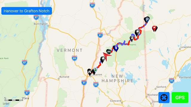
Whew, 14.5 miles today! Early this morning, we set out and began climbing to the 8-mile-long ridge of Moose Mountain (north peak elevation 2,311 feet). Only the northern half of the ridge is on the Trail. Between North Moose and South Moose, we passed Moose Mountain Shelter (Mile Marker 431.2). The closer we got to Hanover, NH, the wooded sections began to get shorter and road crossings became more frequent. The Trail descended as we crossed Three Mile Road, Etna Hanover Center Road and Trescott Road. As we climbed up and down several unnamed hills, we passed the last New Hampshire camp, Velvet Rocks Shelter. After that, we entered the town of Hanover on the southern edge of Dartmouth College. The town felt really crowded and not my kind of place, but they seemed to treat hikers well—I guess they don't really have a choice since the Trail cuts right through their town (the red line on the map below). I had to pick up two resupply boxes (one containing my two alternate backpacks), so I decided to spend the night at the motel where they were sent. I sure had second thoughts when I saw the bill, but it should feel really good to sleep in a bed again tonight.


After I sort out and reorganize my pack and resupply contents, I'll figure out which of my old backpacks to use and then mail the ZPacks backpack home along with whichever pack I decide not to use. Once that's all done, I will be walking out of New Hampshire and into Vermont in the morning! One more state down; boy, progress sure feels good.

Wednesday, September 5, 2018

Smarts Mountain, Trapper John Shelter and Holts Ledge

We left camp this morning, and headed along the ridges for 4 miles up to Smarts Mountain (elevation 3,200 feet). The views were beautiful from the summit, which included a fire tower and the Smarts Mountain Cabin Shelter (Mile Marker 418.8), which used to be the fire warden's cabin. I decided to take a break there for lunch and called my wife while I had a cell signal.

The hike down the mountain was quite a bit steeper than the climb up had been. We walked across Lambert Ridge and down to the Smarts Mountain/Dorchester Road Trailhead, where we crossed Grant Brook. After a couple of miles, we passed Trapper John Shelter (Mile Marker 425.5), which was named after the character from the TV show M*A*S*H*. Then, the Trail climbed steeply to the top of Holts Ledge (elevation 2,110 feet) and then dropped just as steeply down the other side. We crossed Hughes Brook, where we decided to collect water and camp near Goose Pond Road (Mile Marker 428.2). We totaled about 13 miles for the day.

Mt. Cube and Hexacuba Shelter

Yesterday, we continued past Ore Hill (where we crossed Ore Brook) and Sentinel Mountain and hiked through Sentinel Mountain State Forest. Each time we cross a brook or stream, I let Forest stand in the water to cool off a little, so that helped us keep moving. We stopped to collect water from the Pond Brook, which connects Upper and Lower Baker Ponds, near Bakers Hill Rd. (NH 25A) and set up camp nearby for the night.

This morning we had to hike a long 6-mile stretch where there was no reliable water source, so we were carrying extra water. The Trail rose gently for about a mile after crossing the 25A Trailhead (Mile Marker 408.5) and then began to climb more steeply to the rocky summit of Mt. Cube (elevation 2,909 feet). We took a quick break there for lunch and to speak with my wife briefly while I had a weak cell signal.


The descent down Mt. Cube included granite slabs and a rockfall, so we were glad it wasn't raining. Not far down the Trail we passed Hexacuba Shelter and crossed Jacobs Brook. We decided to collect water and camp there, leaving Smarts Mountain for the morning.

Monday, September 3, 2018

Wachipauka Pond and Mt. Mist

Our hike today took us on a leisurely walk down the Trail, winding through the forest and up and down gentle hills. We passed Wachipauka Pond and went up and down Mt. Mist. It was a relatively easy day, but now that we're in lower elevations, the heat is slowing Forest down. It's been in the low 80s, so we've been taking frequent drink breaks. The temperatures are supposed to drop significantly later in the week, so we'll be able to move faster and farther then.


Our goal for the day was just past Mt. Cube and Hexacuba Shelter, which would be 15 miles. I'm not sure if we'll make it that far because of the heat. Forest will be calling the shots.


I forgot to recharge my phone last night, so I have to save what is left for Guthooks.

Sunday, September 2, 2018

Leaving Hikers Welcome Hostel, Glencliff, NH

After I got up this morning and had breakfast, I began to work on a way to fasten the hip belt back onto my pack, since it still has to get me to Hanover, NH, about 44 miles away. I was able to fix it for now using a piece of metal I filed smooth. It's probably hard to tell from these photos, but in the top two pictures, you can see the pack, the part that broke and the hip belt (all lying on blue carpet). The bottom picture shows the piece of metal that I used to reattach it.


After making a dinner run, I was ready to pay my bill at the hostel and head back down the Trail. Hikers Welcome Hostel was a good place to stay, but they only had bunkhouse and camping options. We stayed in the bunkhouse. As usual, I didn't sleep well in a room full of strangers, but I was glad to have a bed instead of having to sleep on the ground.

I plan to just hike 1.7 miles around Wyatt Hill tonight. Tomorrow, we'll get an early start and hopefully knock out 10-15 miles.

Saturday, September 1, 2018

Slackpacking from Kinsman Notch to Glencliff, NH (NH 25/Moosilauke Rd.)

We headed out to slack pack the section we shuttled over yesterday at 8:30 this morning. This section included Mt. Jim, Mt. Blue and Benton State Forest, but the major attraction was Mt. Moosilauke, the southernmost high peak in the White Mountains (elevation 4,802 feet). Beginning at Kinsman Notch and hiking south, Forest and I hiked about 10 tough miles in 4 hours. Climbing up Mt. Moosilauke was essentially climbing up a waterfall, which we had to do very carefully. It wasn't fun; I'm so glad to be done with the White Mountains.


We have now hiked 1,108.3 miles, which means that we are over the halfway mark for the Trail. The hardest parts are done, and in about 40 miles, we'll say goodbye to New Hampshire and hello to Vermont.


We got back to the hostel in Glencliff in good time. I got a cheeseburger for dinner and began working on my pack, so it will make it through to Vermont. The good news is that ZPacks has said they will fix my pack no matter what happened to it. It's great working with these companies that are so supportive of hikers.

How It All Began

In August 2017 Canines for Service Inc. in Wilmington, NC, provided Service Dog Forest to me (U.S. Army Veteran "Fisher"). It was ...